


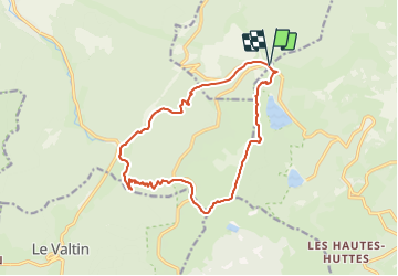
Le Gazon du Faing depuis le Rudlin

vaillantjm
User


5h30
Difficulty : Difficult

FREE GPS app for hiking
 SityTrail
IGN / Geographical institutes
SityTrail Plus
The world is yours!
About
Trail Walking of 14.4 km to be discovered at Grand Est, Haut-Rhin, Le Bonhomme. This trail is proposed by vaillantjm.
Description
Belle randonnée, plus exigeante qu'il ne le parait de prime abord. La montée du Rudlin au Gazon du Faing est assez longue (500 m jusqu'à l'auberge 100 m jusqu'au sommet). Restauration possible à cette auberge et repas tiré du sac contre consommation, en terrasse. Nombreux sentieux rocailleux, mais le sentier le long du Ruhlock est magnifique.
Pour des raisons logistiques, le départ à partir du Rudlin est conseillé.
Positioning
Comments